Organisation
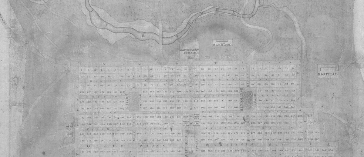
ContributeSurveyor-General Colonel William Light fixed the location of Adelaide on the last day of 1836. He then surveyed the site between January and March 1837, drawing up a plan for the commercial centre and North Adelaide. Streets were carefully laid out in a grid formation and the city with its six squares was surrounded by parklands.
An acrimonious affair
But the naming of what became the main streets and places of Adelaide and North Adelaide was not a harmonious affair. Conflict between Governor John Hindmarsh and Resident Commissioner James Hurtle Fisher over their respective powers extended to even this aspect of the organisation of the colony. Emigration Agent John Brown, who had little regard for Hindmarsh, noted the discord and the compromise of a Street Naming Committee in a letter to Edward Gibbon Wakefield in England. In May 1837 he wrote: ‘We have had the streets named. Now the Governor claims this as his prerogative. Mr Fisher differs, but not anxious to retard the whole issue, proposed that a few of the principal individuals should do it. 12 accordingly met’.[1]
The committee comprised Hindmarsh, Fisher, Brown, Light, Osmond Gilles (Colonial Treasurer), John Morphett, Edward Stephens, Sir John Jeffcott (Colonial Judge), Robert Gouger (Colonial Secretary), Thomas Gilbert (Colonial Storekeeper), John Barton Hack and Thomas Bewes Strangways. It selected the street names at a meeting on 23 May 1837. In Brown’s version of proceedings:
The Governor brought a pocket full of Royal & Naval Heroes, but afraid of proposing them himself, got Sir J Jeffcott to try. K William Street & Victoria Square were agreed to by all, but when he got to Duncan & Howe as his two next, we divided, & Grote and Wakefield reigned in their stead. This nearly ended the question & we came off with only Malcolm & Tynte & Strangways. I am rather ashamed of myself of having my hand in this business, but votes were wanted, or it would have been a Journal of our Governor’s life & adventures.
Hindmarsh found it difficult to accept the outcome and he appears to have had some street names altered after the meeting. The main street names determined by the Street Naming Committee and incorporating Hindmarsh’s amendments were gazetted on 3 June 1837. The naming of minor streets and laneways occurred as the city developed.
[1] State Library of South Australia: PRG 1002/1/67, Brown Papers, Letters relating to the foundation of the colony, vol. 2
Destroyed by fire?
Sadly, the minutes of the Street Naming Committee have been lost and with them the opportunity to find out more about its deliberations. On 22 January 1839 at 2pm, a day after Light ceased work due to illness, his hut and the Survey Office on North Terrace burnt to the ground. The fire had commenced in Fisher’s residence, which it destroyed along with the Land Office. The Southern Australian of 23 January 1839 reported that both ‘extensive ranges of buildings’ were ruins within 20 minutes. While various official records and maps in the offices were saved, Fisher and Light
had to witness the total destruction of their houses, furniture, books, a considerable quantity of live stock consisting of pigs, poultry, &c., and, what is beyond all the rest, being irremediable, their private accounts and papers. Scarcely an article of any value has been saved by either party from the devouring element. At Mr. Fisher's also were destroyed nearly all the books and papers belonging to Messrs. Fisher, brothers ; and amongst in Colonel Light's losses we must include several of his instruments, the whole of his valuable portfolios of drawings executed during his residence in Egypt and in the Peninsula, and what as colonists we yet more regret, the private journal he has diligently kept for the last 30 years. So rapid was the progress of the flames that the inmates in either residence had scarcely time to escape.
Almost two years later a fire in the vicinity on 12 January 1841 destroyed ‘nearly all the records and documents connected with the legislative and executive departments of the Governments’ when Government Hut burned to the ground. The South Australian Register of 23 January 1841 reported that this was an apparent arson attack shortly after the papers had been moved there to make room in Government House for Lady Franklin, the wife of Tasmania’s governor.
As for John Brown’s records, his dwelling on the northeast corner of East Terrace and Angas Street was destroyed by a fire on 30 November 1839 and most of the contents, including journals and papers, were incinerated too.
The minutes of the Street Naming Committee were almost certainly among documents destroyed in one of these fires.
Media
Add mediaImages

Image courtesy of the State Library of South Australia SLSA: B333, Public Domain.

Image courtesy of the State Library of South Australia SLSA: B349, http://images.slsa.sa.gov.au/mpcimg/00500/B349.htm, No known copyright restrictions

Image courtesy of the State Library of South Australia SLSA: B5836, http://images.slsa.sa.gov.au/mpcimg/06000/B5836.htm, No known copyright restrictions


Comments
CommentAdd new comment
I agree Rozee, some incredibly valuable sources have been lost in tragedies like those fires, but the challenge of piecing together the puzzle of history I think is what a lot of people find most interesting.
What a tragic loss! - One cannot imagine the treasures lost to historians and to posterity by these fires. - So very sad indeed. - PJ.