Subject
ContributeA flood is a rising body of water that overtops its natural or artificial confines to cover land not usually under water. Such events are frequently referred to as 'flash floods' for they are temporary events. Lake levels rise as a result of heavy rains and overflow, flooding adjacent areas. Runoff accumulates in usually dry depressions forming ephemeral shallow sheets of water. Most South Australian floods, however, are associated with rivers.
Lake Eyre
Several major rivers like the Diamantina–Warburton, and the Thompson–Barcoo–Cooper systems run toward Lake Eyre, the lowest point of which stands 15–16m below sea level, and which is located in the driest part of Australia. But given two or more consecutive years of heavy monsoon rainfall, the larger rivers flow into the lake. It has been filled several times, and was in flood in 2011. The highest recorded stand occurred in 1974 when the water rose to -9.09m and stabilised for many weeks at -9.5m; but prehistoric stands of Lake Eyre up to 2.6m higher than the 1974 water level are attested by the geological evidence. The record of water levels in the salina is, however, complicated by its long term and continuing subsidence. During such floods the surrounding desert is inundated with water spreading along the interdune corridors. Groundwaters are replenished, tanks and dams filled, and the desert blooms, to the benefit of the pastoral and tourist industries.
The River Murray
The River Murray is long but its discharge is low. Nevertheless, heavy rains in the headwater regions occasionally cause flooding downstream. For example, in 2011 the river ran high as a result of heavy summer rains in the Darling River catchment. Because in South Australia the river flows in a gorge, only minor flooding occurred, and only in the immediate vicinity of the channel, but the many lagoons adjacent to the main channels, previously dry, were filled.
Early Floods
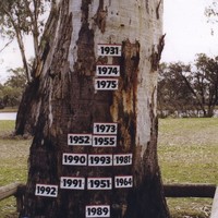
Several notable earlier floods are recorded. That of September 1956 was the highest since European settlement though evidence preserved in an archaeological excavation near Walker Flat shows that about 3000 years ago the river may have stood some 25cm higher that the 1956 event, when the valley floor was inundated and parts of river towns were under water. People rowed boats down the main street of Mannum, and much of Renmark and the surrounding district was under water. Just as flooding in coastal areas is exacerbated by the coincidence of high river levels with high tides, so the Goolwa Barrage, constructed in 1940 near the mouth of the River Murray to prevent seawater spreading upstream at times of low river level, caused a secular rise in river level of about 50cm as far north as Blanchetown.
Flood Prone Areas
Local floods are frequently experienced in and adjacent to the Flinders and Mt Lofty Ranges, the Cleve Hills and the Lincoln Uplands. In Adelaide, floods on the Torrens have been recorded from the earliest days of European settlement. The river rises in the Mt Lofty Ranges, and after leaving its gorge receives runoff from five tributaries (First to Fifth Creeks) draining the western Ranges. It then flows in a confined valley through the city to the vicinity of Lockleys, below which it runs on to the plains.
Before the implementation of flood mitigation schemes (such as the City Weir in 1881), several areas behind the coastal dunes between Port Adelaide and north Glenelg were inundated whenever the river ran high, and were boggy at other times. Around Fulham and Henley Beach the Reedbeds was a swampy area notorious in summer for its mosquitoes. Even in relatively high areas like Brompton and Lockleys, the river occasionally overtopped its banks. In addition, various metropolitan tributaries of the Torrens – First through to Fifth Creek – as well as the Sturt River drainage, at times, as in 1920 and 1934, also run high and cause local flooding.
Impact
The Kangaroo Creek Dam, constructed in 1969, has reduced the likelihood of floods on the Torrens, although the building of houses and structures and the paving of roads causes more rapid runoff and favours downstream flooding. Many other Adelaide Hills towns such as Verdun and Strathalbyn are prone to floods and Adelaide Plains settlements, particularly those like Gawler, located on rivers debouching from the uplands on to the plains, are not immune.
Floods are costly. Imprudence and bad luck have cost lives. Even in the driest State in the driest inhabited continent floods are a threat. Streams occasionally appear and rise after heavy rains on the seemingly riverless northern Eyre Peninsula, causing main roads to be blocked. The greater the spread and intensity of settlement, the more frequently and the more damaging will this nuisance become. At present, however, and paradoxically, the only parts of South Australia that experience occasional serious disruption of transport and communication by flooding are the sparsely populated deserts around Lake Eyre. South Australia does not suffer the devastating floods experienced all too frequently on the east coast and associated with the unconfined River Murray in northwestern Victoria.
Media
Add mediaImages

History SA. South Australian Government Photographic Collection, GN01956

Image courtesy of C.R. Twidale. Not to be reproduced without permission

Image courtesy of C.R. Twidale. Not to be reproduced without permission


CommentAdd new comment
Quickly, it's still quiet here; be the first to have your say!